A Walk With Dinosaurs and Romans

One of the perks of getting older is retirement or, in my case, semi-retirement.  Suddenly, I no longer need to keep checking my watch to see if I have enough time to do things without racing onto something or somewhere else.  It has given me time to re-visit some of the pleasures that I enjoyed in the past. One of these is walking.  When I was much younger I used to walk the long-distance footpaths and trails that were then just beginning to be created.  Now there are literally dozens of them to be enjoyed varying in length from a few dozen miles to several hundred.  I’m not up to the lengthy walks of my youth yet – the longest took a fortnight to complete.  At present, I’m content to be out for a few hours and, hopefully, the mileage will increase over time. 

England is criss-crossed by public footpaths and longer trails

The other day my partner and I decided to visit the Roman villa at North Leigh not far from the small, Cotswold town of Woodstock.  Unlike the Roman villa where you rarely see anyone, Woodstock is visited by thousands of international visitors every year, for it is where Blenheim Palace, a World Heritage Site, is located.  The two houses, six miles apart in distance but fifteen hundred years apart in their building, are very different.  Whereas the Palace is full of priceless treasures, all that is left of the villa are the foundations and a single mosaic floor.  At its peak in 300AD, the villa was one of the largest in Britain with suites of rooms, many mosaics and several baths.  Now it is quiet, wildflowers scramble over the walls and it is set in glorious countryside close to the River Evenlode.  With parking close-by, this was the starting point for the walk.

The Roman Villa, once busy – now a haven of peace and quiet
Wildflowers scramble over the ruins of the Roman villa

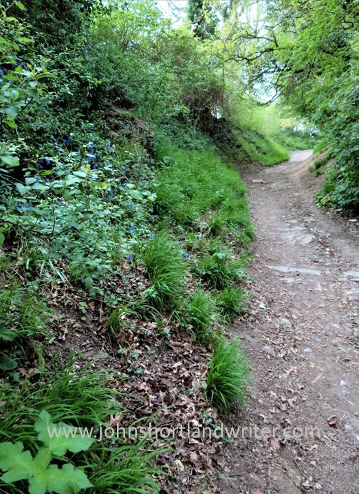
The path to the villa and those leading away from it are well maintained and marked, making the trail easy to follow.  Most of the route we took was on the network of public footpaths that criss-cross England, most of them dating from the time when all travel was either on foot or horse.  At one point, the paths joined the Oxfordshire Way, a path of 66 miles in length.  This in turn links to other long-distance paths so how long you walk for is entirely up to you!  After ten minutes or so, the Evenlode was reached and crossed.  Originally known as the Blade, its present name is relatively modern, first being recorded in use in the 1880s.  It meanders through the Cotswolds for nearly fifty miles before entering the River Thames. Crossing the river, the path turns to the west and the country changes in character with steep grassy banks rich in wildflowers rising high to our right, the river to our left.  Here we’re walking along Akeman Street, an ancient Roman road, once busy but now a quiet, grassy track.

The paths cross meadows until the river is reached

“The tender Evenlode that makes her meadows hush to hear the sound of water…”

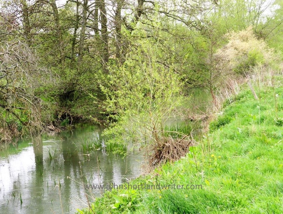
Before long, the character of the path changes once more.  The Evenlode changes in character too for there is a wide ford – perfect for wild swimming.  Various paths meet here but we walked the steep path towards the village of Stonesfield, known locally for its history of making the stone rooftiles that are a feature of old Cotswold properties.  In pre-history, the Cotswold Hills were submerged by a warm sea and now fossils can be found quite easily; they can even be seen occasionally in the stones that have been used to build the houses.  It was in the Stonesfield loose and flaky rock that the very first dinosaur fossil to be found anywhere in the world was discovered.  Close to where it was found, a steel bench inscribed with the words of the French poet Hilaire Belloc has recently been placed – welcome indeed, after clambering up the steep path that leads from the ford to the village.

The view of the river from the ford
The rocks around the village of Stonesfield yielded the world’s first dinosaur fossil
The steel bench engraved with the words of Hilaire Belloc

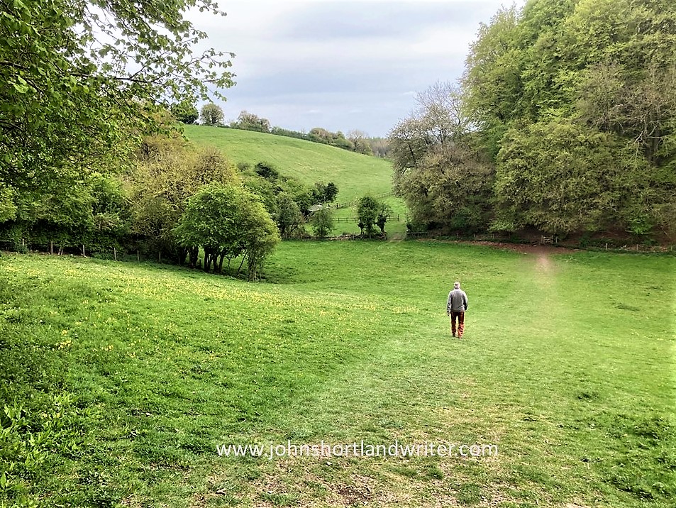
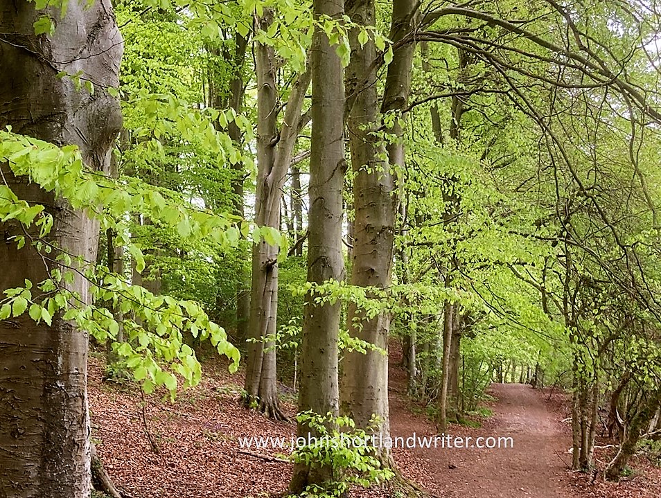
After a short walk along the edge of the village, our path left the Oxfordshire Way to descend steeply through meadows before reaching a strip of woodland, Stockey Plantation.  Although there are firs planted there, there are also many native beech trees which are, arguably, at there most glorious at this time of year.  The newly unfurled leaves are of the most intense green which, along with the deep blue of bluebells and the yellows of other spring flowers are almost too bright for the eyes to bear.

The descent to the woods becomes more gentle as it crosses the meadow
The path through the beechwood
The intense colours of the beech leaves and bluebells almost hurt the eyes

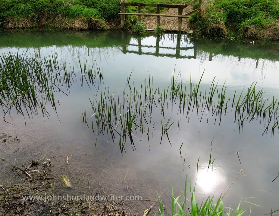
Leaving the woodland we reach the Evenlode ford once more but this time cross it – there is a footbridge, so no need to get wet – before striking off across the fields again to return by an alternative route to the Roman villa and the car beyond.  The walk probably took no more than a couple of hours and is relatively easy.  The weather, this April has been very dry.  At other times, the paths can be muddy and so sensible, walking shoes or boots are recommended.  The route we chose does have some steep hills to climb but these can be avoided for there are many paths that keep to the level ground.  An Ordnance Survey map of the area is handy to work out routes – I used the app on my phone but paper maps covering all parts of the UK are readily available. 

The sun seemed to shine brighter in the water than overhead
In the damper woodlands Ramsons, the wild garlic, carpeted the floor

To see more photos of the Roman villa and read of its history take a look at one of my earlier posts by clicking on the link here.

To read the full text of Hilaire Beloc’s poem of the Evenlode river click here

Advertisement

A Sudden Escape

Sometimes it is good to plan and sometimes it is good to be spontaneous. I certainly have proved the latter in the past few days by surprising my family when announcing that I thought I would spend a couple of days away in Sidmouth. “When are you thinking of coming down?” my sister had asked. “Now,” was my response, “can you provide a bed?” I arrived a few hours later.

Sidmouth, a small, Regency resort on the south coast of Devon lies about 170 miles to the south-west of the Cotswolds. Devon, along with Somerset and Cornwall, are three English counties collectively known as “The West Country” and a prime tourist destination. A long peninsula reaching out into the Atlantic Ocean, it has many spectacular cliffs and sandy beaches and these, combined with a benign climate, make it the place where many Brits go for their summer holidays. Inland, it is a country of traditional farming, fast-flowing streams and open moorland and remains one of the few areas where it is possible to roam freely without too many restrictions. It is also home to several National Parks and long-distance footpaths.

Sidmouth (4a) copyright

Sidmouth came to prominence during the 1800s when in 1819 the Duke of Kent came to stay with his young child, Victoria. During this stay he died yet despite this inauspicious start the small fishing village became a fashionable place to visit. Later, after Victoria ascended the throne, she gifted to the church a memorial window which in recent times has been restored, partly funded by a further gift by our present Queen. Much of old Sidmouth is now a conservation area and buildings along the Esplanade, the seafront road, are classic examples of those built during this time.

Sidmouth 15 watermark

The Esplanade

Like many coastal towns, Sidmouth is at the mercy of winter storms and with no natural sheltered harbour to protect it, when the sea batters the town it suffers, although not as badly as might be expected. However, it is the exposed sandstone cliffs that bare the brunt of these storms. Erosion is a real and constant threat and the red cliffs of Salcombe Hill are constantly crumbling. A number of houses are at serious risk of collapse in the forthcoming years. The cliffs form part of the Jurassic Coast, a World Heritage Site, renowned for its rock formations and fossils.

Sidmouth (15) watermark

Not there for much longer…

Sidmouth (9) watermark

Modern fossils!

Away from the crumbling cliff, there are two beaches. The Town Beach is of pebbles, reinstated after a 1990s storm washed it away. It is now protected by manmade rocky outcrops. At the far end of town is Jacob’s Ladder beach, so-named after the series of zig-zag wooden steps that lead down to it from the clifftop. This beach is a combination of sand and shingle. Both beaches are popular in the summer when the water is warmer; now, in February, the sea looks less inviting.

Sidmouth (1) watermark

Jacob’s Ladder Beach in midsummer

Sidmouth - waves (1) watermark

The Town Beach in February

The mild, coastal climate protects many semi-tender plants which further inland would suffer damage from frosts. Connaught Gardens, a public space that date from the 1820s, are a riot of colour during the summer months and each year a number of private gardens also open to the public under the National Gardens Scheme.  Although these can be lovely, for me the jewel in Sidmouth’s crown is the area of natural parkland known as The Byes. A 2km green corridor that follows the course of the Sid river, it has a good path network, some outstanding trees as well as wildflower meadows. It is a good place to spot wild birds such as kingfishers and dippers. Popular with residents, it seems less well-known to visitors.

Sidmouth (12) watermark

The Connaught Gardens in midsummer

Sidmouth (16) watermark

The Byes

During the first week of August, at the height of the tourist season, the Sidmouth Folk Festival takes place. First held in 1955, it attracts some of the top names in the country. Apart from the listed acts, others sit around the seafront playing and busking, greatly adding to the atmosphere. When it all proves too much, there is always the opportunity to sit on a deckchair and take a nap in the summer sun.

Sidmouth Folk Week 2014 (5) copyright

Fiddling on the beach

Sidmouth (6) copyright

Finding Blue John

Recently I spent a long weekend in the Peak District – not really long enough to explore properly despite it being Britain’s smallest national park.  However, there was time to explore the small town of Bakewell, home of the famous and very tasty Bakewell Tart as well as a drive through the Chatsworth Estate.  The ancestral home of the Dukes of Devonshire had to be ignored on this occasion but lunch at their farm shop was well worth breaking the journey for. For photographs and a description of these places see my earlier post by clicking on the link The Peak District’s Soft Centre.  Finally reaching the area known as the High Peak (despite the name there are no mountains in the Peak District) a roadside sign pointing in the direction of Blue John led through glorious countryside.

Chatsworth (1) watermark

Chatsworth House

Blue John Mine (2) watermark

View from the Blue John mine

Blue John is a fluorite semi-precious mineral that in its raw state appears quite dull.  After drying, preparing and polishing it takes on a number of colours ranging from purplish-blue through to yellow.  Despite numerous tests and analyses the origins of the colour has not been discovered.  Blue John is also a rare stone for although similar minerals have been found elsewhere in the world there are only two known places where its unique quality can be found – and those are both in the same hillside in the Peak District.

Blue John Mine (3) watermark

Blue John in its raw state

1280px-Cliff_Blue_Vein_Bowl_-_Castleton_Visitor_Centre

    Blue John after processing – the bowl is in the Castleton (Peak District) Visitor Centre.         Copyright: Pasicles via Wikipedia

Visiting the Blue John mine is not for the faint-hearted or the short-of-breath for that matter: there are two hundred and fifty steps to descend and then, of course, you have to climb back up them to reach the surface once more.  Don’t complain, ‘though, or you may have to descend by rope as the early miners once did.  Fortunately, I only looked down it to see the visitors below.

Blue John Mine (11) watermark

The descent into the mine

Blue John Mine (4) watermark

The alternative way into the mine – being lowered by rope!

Inside the mine there are low tunnels to pass through contrasting with vast caverns with roof heights of 200 feet or more, either created by ancient rivers or by the miners themselves.  Each cavern has its own unique characteristic although it is difficult to catch it on camera.  The one below is named Lord Mulgrave’s Dining Room, a huge circular space formed by a whirlpool and so named after the dinner Lord M gave his miners there.  The thought of the cooks and food being lowered deep into the mine gives a new angle to the term ‘outdoor catering’!

Blue John Mine (5) watermark

Blue John Mine (14) watermark

Lord Mulgrave’s Dining Room

The Waterfall Cavern is colourful with the stalactite formations along one side appearing to be frozen water.  Elsewhere there are numerous fossils where marine animals have been ‘captured’ for posterity.

Blue John Mine (8) watermark

‘The Frozen Waterfall’

Blue John Mine (22) waterfall

Fossils embedded into the mine walls

Throughout the mine the colours and texture of the rock formations are extraordinary and constantly changing.  In one cavern it is easy to ‘see’ the rocky and meandering bed of the prehistoric river that formed it, the difference being that it is way, way above one’s head.  In another, a giant, triangular rock has fallen to balance on its point.

Blue John Mine (16) watermark

The overhead ‘riverbed’

Blue John Mine (12) watermark

Huge and precariously balanced

The tours, which are led by miners, for Blue John is still mined here during the winter months, last about an hour.  At the end of the tour all there is left is to climb the two hundred and fifty steps back to the surface…

Blue John Mine (19) watermark

The long climb back to the surface


For further details of the history of the Blue John Mine and visiting hours visit their website here.

To give overseas visitors a better idea of its location, the Peak District National Park is approx. 3.5 hours by car, north from London; by public transport allow 6-7 hours.  There are plenty of hotels, traditional pubs and self-catering cottages available for overnight stays.