A Walk by Stonehenge – part 1

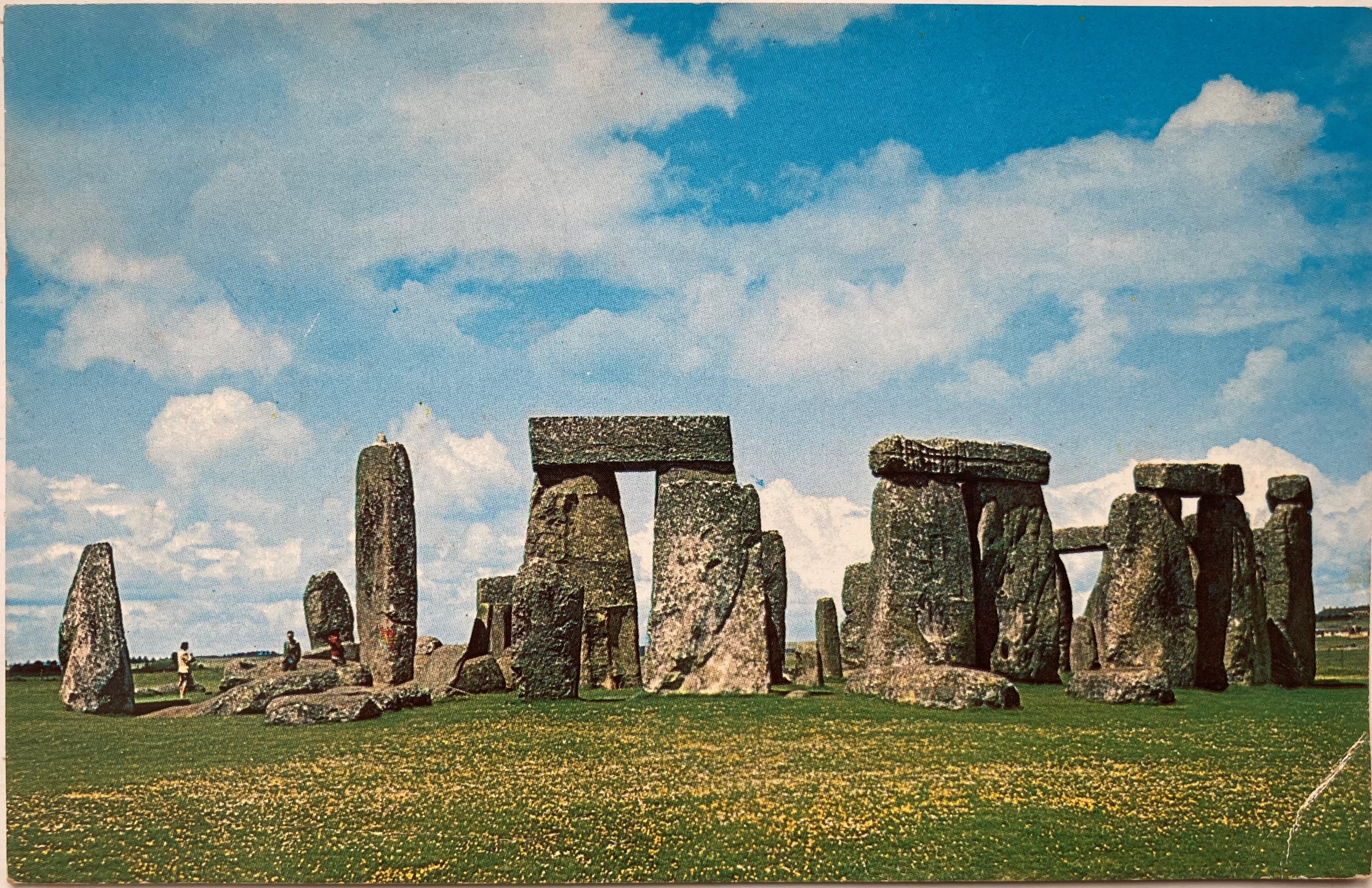
It is many years since I last visited Stonehenge, the prehistoric standing stones so closely attuned to the midsummer solstice.  Renowned throughout the world, it has been listed as an UNESCO World Heritage Site since 1986.  With fame comes numerous issues, not least how to cope with the estimated one million visitors that come to see them each year.  To prevent damage to the stones through soil erosion and, surprisingly, physical damage through the chipping off of ‘mementos’, the stones are now cordoned off.  This fencing is removed to allow access at the time of the midsummer solstice, a time when hundreds of people wait through the night for the midsummer sun to rise directly between the stones.  The image below is of a postcard that my great-aunt sent me in 1963 when the stones were much less frequently visited and reminds me of those early years when I used to play amongst them.

Stonehenge was far less visited back in the 1960s!

The Stonehenge World Heritage Site covers an area that includes other Neolithic standing stones close by.  A few miles away, and unlike Stonehenge, a place where you can walk amongst the stones every day of the year, is Avebury.  This circle is huge and considerably older than Stonehenge: flint tools dating back 9000 years show that early man was passing that way 4000 years before Stonehenge was built.  Avebury is the place to visit if you want to get close enough to touch the stones and it is also completely free to visit.  To visit Stonehenge can be quite costly although there is another way you can see the stones (legally) without paying if you’re prepared to walk – see below.

Avebury Stone Circle – part of the Stonehenge World Heritage Site

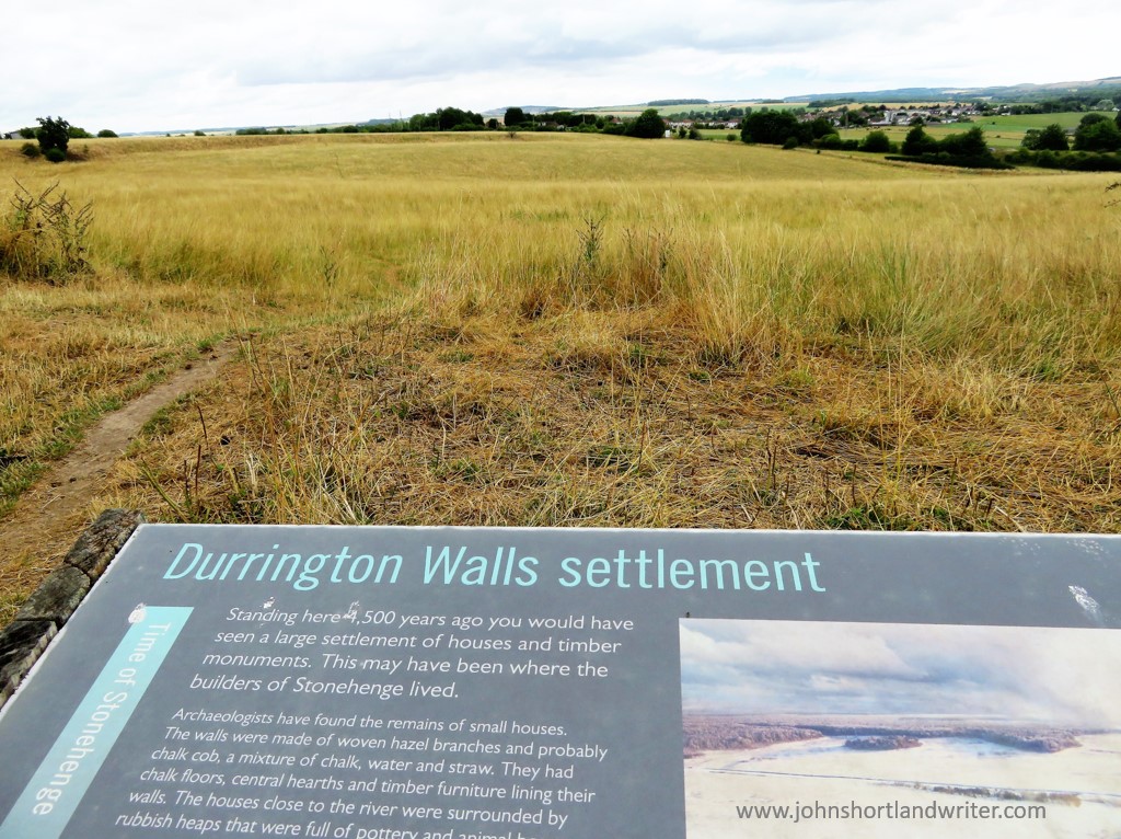
The third site, and to my mind, the best one for you will almost certainly have the place to yourself, is known as Woodhenge & Durrington Walls.  To be really impressed by this comparatively unknown place you do need to know some background information of its history plus a vivid imagination.  For me, it is such an atmospheric place to visit that the latter has never been an issue!  I recommend starting your walk here and walking inside the circle of Durrington Walls before exploring Woodhenge.  The first thing that is noticeable about Durrington Walls is that there are no walls!  The circular bank and ditch that surrounds the site was enormous and consisted of the bank itself which would have been several metres high.  The ditch originally was over five metres deep and, in places, up to thirty metres wide.  It is estimated that between four and six thousand people would have been needed to build the walls as well as the various houses and large timber circles associated with the site.  A feat quite remarkable nowadays let alone over four thousand years ago using just antler pickaxes!  Although nothing remains above ground now, apart from the bank, I found it very easy to imagine, as I walked alone and in silence, the bustle and noise of these industrious people.

Within Durrington Walls, now a grassy bank, up to 6000 people once lived
Information boards help you to understand the context of what you are not seeing!

Leaving Durrington Walls I made my way to the Cuckoo Stone, my only companions, sheep.  Now fallen, this stone would originally have been placed upright.  Looking at maps, it appears to be more, or less in line with the Great Cursus (more about that below) which in turn leads to Stonehenge.  The Cuckoo Stone, positioned 4000 years ago, continued to be ritually used into Roman times for in 2007, during archaeological excavation, a small building thought to be a shrine from that period was discovered. 

Close to the Cuckoo Stone a Roman shrine once stood

Leaving the Cuckoo Stone, my path led to an old track edged by wildflowers humming with bees and butterflies and bringing me out at the top of the Cursus.  The Cursus is another huge earthwork showing nowadays as a crop mark – two bright green stripes in an otherwise darker landscape.  If you compare my photograph with the one of the information board (below), I was standing at the opposite end.  In my image, the end of the Cursus can just be made out on the far horizon almost two miles distant.  The purpose of the Cursus is unknown but thought to be ceremonial as it is again aligned to the summer solstice.  It is even older than Stonehenge having been constructed several hundred years earlier.

The two-mile long Cursus now only shows as two grassy green stripes
The Cursus is better understood from this aerial photograph

Another good track took me due south before turning west to Old King Barrows and then back south to New King Barrows.  Before leaving the Cursus I stood to watch the visitors to Stonehenge some long way off and thinking how lucky I was to have all of this unseen history of the World Heritage Site to myself with only the song of skylarks as company.  More than five thousand years separated me from the Neolithic people yet surely, they must have stood here too and seen a similar picture as they made their way to join others already arrived, a humbling thought.

A distant Stonehenge can be clearly seen from the Cursus

The Old and New King Barrows consist of two groups, each of seven burial mounds so fourteen in total, separated by Stonehenge Avenue which is only visible as another cropmark.  The Avenue linked Stonehenge to the River Avon almost two miles away and was, perhaps, another route the Ancients would have taken to reach the stones. Despite their name, the Old and New King Barrows date from the same time period, and also around the same as Stonehenge.

One of the prehistoric burial mounds at Old King Barrows

It was by the barrows that I turned back towards Woodhenge, the last part of my relatively short but extraordinarily rich walk, rich both in its views and its wildlife, as well as its history.  As if to bring me almost up-to-date in time, the sound of an old-fashioned binder in an adjoining field was busy bringing in the harvest.  Not quite twenty-first century but a common sight less than a hundred years ago.

Harvesting wheat the old-fashioned way


The final part of my walk to Woodhenge will be published shortly.

To visit Stonehenge for free involves a walk not dissimilar to this one.  Park in Durrington village and take the public bridleway path (where it meets Fargo Road) directly south to Stonehenge.  The path passes the stones within yards of the public viewing path so you will still be separated from the stones.  Public footpaths continue southwards, criss-crossing an area rich in more barrows and other ancient earthworks.  With the help of an Ordnance Survey map it should be quite possible to make a longer, circular walk.

**Click on any of the images to enlarge**

.

Advertisement

Three Very Special Cotswold Reasons – revisited

Back in 2009 – which seems a lifetime ago now – I responded to a question posed by The Guardian newspaper and the English tourist authority: select three things that make a place very special. Naturally, I chose the Cotswolds and to my delight, my blog was just one of ten chosen and published by them to promote visits to this country. After fourteen years, I thought it time to take another look. Although the reasons still stand up well I’ve updated the photos and some of the text.

You’ll know when you arrive…

1. Space and Peace. I know this is technically two reasons but they are so interlinked that, in my mind, they only count as one. Besides, that way I can cram in an extra reason without appearing to cheat too much. The flat topped, rolling limestone hills that make up the Cotswolds offer far reaching views to the vales beyond. They free the mind and let the spirit wander – a rare occurrence in the busy world we all inhabit. This view looks north over glorious country to the Vale of Evesham and just invites you to start walking towards a distant goal.

Hidden in deep valleys, crystal clear streams create more secretive places to explore or to sit quietly by their banks to watch the water flow, sometimes gently, sometimes more noisily, by.

The River Evenlode

The King’s Men stone circle forms part of the Rollright Stones and have been a meeting place since they were set here 4,500 years ago. In early morning light they appear mysterious and brooding but when the sun strikes them their colours and markings are awe inspiring. Rest here a while, at a time when you can be alone, for the feeling of peace is palpable.

And give back to the soil an offering, (when we have taken so much away), as others have done from the beginnings of time and continue to do so. Single flowers placed at the centre of the circle have a calm simplicity…


2. Nature. It is impossible not to be aware of nature in the Cotswolds, whether it is the magnificence of old trees, the deer crossing roads in front of you or the cloud formations of our large skyscapes. This ancient ash tree has watched centuries of agricultural change take place and, despite modern farming practice, still stands proud in a hedgerow dividing wheatfields. In 2009 the fungal disease Ash Dieback was unknown. It is now thought that the majority of ash trees will succumb to it robbing the English landscape of their beauty. At present, the old pollard seems unaffected but whether it will survive only time will tell.

Since 2009 we have all become so much more aware of the value of dark skies. With so few big towns, the Cotswolds is a place where the nights are darker and the stars shine more brightly.

Deer are common throughout the Cotswolds. Roe and the introduced Muntjac are frequently seen but perhaps the prettiest, when in their spotted summer coats, are the Fallow.

In our rivers and streams, otters, although rarely seen, are now becoming evermore common – something else that has happened since 2009.

There are some exotic surprises too! A macaw outside a garage in Charlbury and alpaca seem to be everywhere, I wrote in 2009. The macaw has gone and even alpaca seem less common now but not far from the secret valley it is possible to see wolves and bear. I don’t think the two facts are connected!

3. History. The Cotswolds are steeped in history and it is the history of wealth and the power it brings. Sheep – or more accurately, their wool – were the originators of this wealth and the region still has a higher population of sheep to humans. But how to illustrate this when there is so much scope to choose from? Bliss Mill, in Chipping Norton, is now converted to luxury apartments but, for most of its time, produced some of the finest tweeds in Britain. I have since written in more detail of the history of the mill, the fire that engulfed it and the strike by the workers that brought poverty and starvation to the town (link here).

The churches of the Cotswolds were also a by-product of wool – the wealth it created is often shown by their huge size in proportion to the numbers of the local population. The photos I originally published were of St Mary’s, Chipping Norton. The ones below are of St Mary’s, Swinbrook; the village was the home of the famous (or, perhaps, infamous), Mitford sisters.

In 1940 the church suffered damage by a stray German bomb during WW2
…the vicar collected the ancient shattered glass which was incorporated into this memorial window

So, come and visit the Cotswolds and decide for yourself. And, in the meantime, select three things that make your special place, special.

A Walk Across Dartmoor – part 2

A riverside path heading north from the village of Postbridge, famed for its ancient clapper bridge, leads into the heart of the moor.  The bridge dates back at least to the fourteenth century and some of the slabs weigh over eight tons.  The ‘modern’ bridge in the background was built as recently as 1780.

Postbridge copyrightPostbridge 2   copyright

At the point where the river turns abruptly westwards are the remains of a beehive hut.  These were used mostly for storage and, compared to many of Dartmoor’s archaeological features which date back millennia, are also of more recent origin and date from the 1500’s.  They ‘disappear’ into the moorland  features but are clearly visible once you know where to look.

Beehive Hut (2)   copyrightBeehive Hut   copyright

Walking further onto the moor and leaving the river behind are the low grey shapes of the Grey Wethers double stone circle.  Sitting close to Sittaford Tor, they are so named for their resemblance to sheep, ‘wether’ being the Old English name for a castrated male sheep.  A tale, often repeated, is of a traveller stopping off at the remote Warren House Inn (where this walk started and will end) who complained of the poor quality sheep in the district.  After a drink or two, he was led to the circles and in the mist mistook the stones for sheep and bought them, only to discover later that he had been fooled.

Grey Wethers Stone Circle (4)   copyright

The two circles of Grey Wethers appear to the eye as one shaped as a figure of eight but an aerial view shows them to be quite separate to one another, sitting side by side.  The circles are of similar size and lie on a north-south axis although whether this is of relevance is unknown.  Numerous theories abound: perhaps the meeting place of two separate groups of people, or possibly they represent life and death. When excavations took place in 1909 a thick layer of ash was found to cover their centres but, again, the purpose of this is unknown.

Grey Wethers Stone Circle (2)   copyright

From Grey Wethers the walk back to the Warren House Inn skirted the edge of Fernworthy Forest.  Hidden behind the trees is Fernworthy reservoir, created by damming the South Teign River.  When water levels are low the remains of an old farm can be seen, as can the remains of a small clapper bridge, drowned reminders of life on the moor in times past.

the remote Warren House Inn

the remote Warren House Inn