Just occasionally nothing prepares you for a visual and emotional onslaught however much you might have read or seen images of it. I had been planning my first visit to Warwick for a few years. Perhaps it is because it is so close to home – about an hour’s drive north from my part of the Cotswolds – that it had taken me so long to actually go there for, when a place is on your doorstep, you feel you can go at any time and so put it off for another day. As it happened, I finally arrived in the town on the first warm, sunny day of spring when the ancient black and white timbered buildings really stood out against the blue sky.

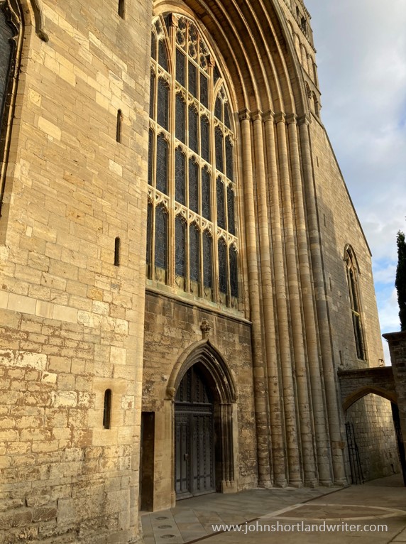
Warwick is even older than those medieval buildings for it has been inhabited since the 5th century. However, it came to prominence when William the Conqueror built Warwick Castle in AD1068. Today, it is possible to visit the castle and even stay there but this was not the purpose of my visit. I had come to see a later building – the Collegiate Chapel of St Mary, most of which is only a mere three hundred years old. A great fire had swept through the town in 1694 destroying much of it as well as the greater part of the original church. Miraculously, the fire was extinguished saving the chancel and the Beauchamp Chapel built during the 14th and 15th centuries. The crypt is all that is left of an even earlier church built over 900 years ago.


I had only been standing in the church a few moments when the organ began to play; the timing could not have been better for it set the mood for the whole visit. Lovely as it was, I moved on quite quickly to the chancel dominated by the tomb and effigies of Thomas Beauchamp and Katherine Mortimer. Both died within a few months of one another in 1369 and their effigies are unusual for they lie there holding hands, signifying not just their undying love but also their equal status for Katherine had brought land and wealth to the marriage. The chancel is also unique for its light and graceful ‘skeleton rib’ vaulted roof simply adorned with the Beauchamp coat of arms clasped by angels.


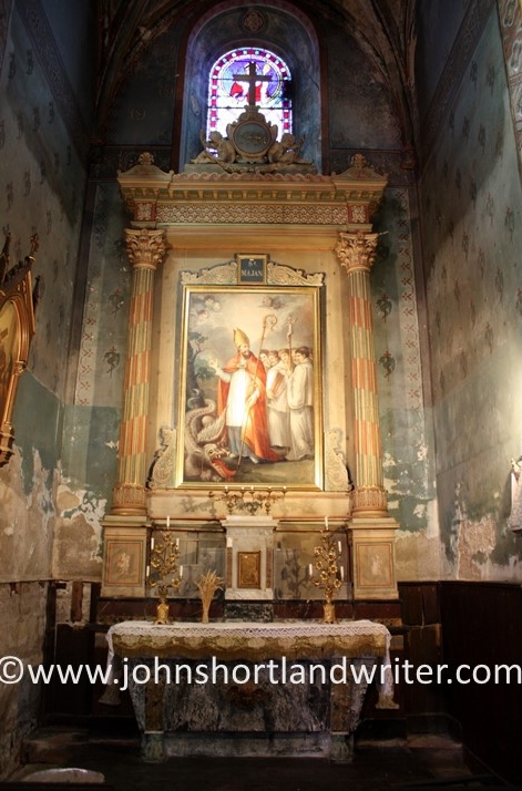
From the chancel it is possible to glimpse into the Beauchamp Chapel where Thomas’ grandson Richard’s tomb stands. I purposely avoided doing so for I wanted to enter the chapel and to see it for the first time in its full glory. As I mentioned in this blog post’s opening sentence, I was completely unprepared for the visual feast that stood before me. The colour, the light, the opulence, the sun-kissed, bronzed effigy of Richard lying there centre stage was pure theatre – just the effect Richard had planned when he left detailed instructions for the building of the chapel all those centuries earlier. With the organ still playing behind me, I stood in the entrance transfixed, feeling slightly silly for being so moved before descending the steps to explore further. I had finally come to see the burial place of my ancestral grandfather.

A short (but necessary!) history of Richard’s life: Richard Beauchamp was born in England in early 1382, the son of the 12th Earl of Warwick. His godfather was King Richard II although within a very few years Richard’s father, also a Thomas, had fallen out of favour and imprisoned in the Tower of London for treason. Fortunately for him at least, the King was deposed and replaced on the throne by Henry IV; Thomas was released and his titles and land restored. During the King’s coronation in 1399, Richard was knighted and later succeeded to the title of 13th Earl of Warwick at his father’s death in 1401. When Henry V succeeded to the throne in 1413 Richard became one of the new King’s most trusted advisers and given responsibility for the education of his young son, later to become Henry VI. Richard then spent much of his time in France, part of which had been annexed during the Hundred Years War and he died there in Rouen on 30th April 1439.


Richard’s body was brought back to England and buried in a temporary grave in the church, for in his Will of 1437 he leaves detailed instructions for the construction of the new chapel to house his tomb. No expense was to be spared for he wanted it to become one of the finest in England, in which he more than succeeded. The creation of the chapel as one complete and new entity, using only the finest materials and highest quality craftsmanship makes it unique – all the more so, for its surviving almost unscathed by the later Reformation, attempted destruction during the Civil War, as well as the great fire. He was finally laid to rest there in 1475.

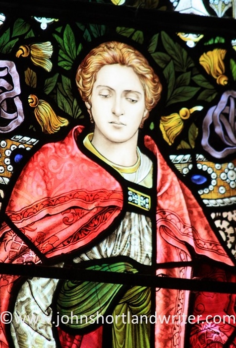
The tomb is, of course, the central feature of the chapel as well as its purpose. Richard lies on an intricately carved and highly coloured marble chest set with fourteen gilded ‘weepers’, namely his children and their spouses. There had been a dispute after Richard’s death within the family over inheritance for Richard had been married twice with children from each. It was Ann that finally inherited the title and estates, a daughter from the second marriage (my ancestor was Eleanor, the second daughter from the first marriage) and so it was she that oversaw the completion of the chapel. Richard’s effigy is of a younger man, his eyes open, his hands outreaching, and dressed in full armour, showing the world that he is ready to enter the Kingdom of Heaven. He gazes upon the stained glass that confirms this story.


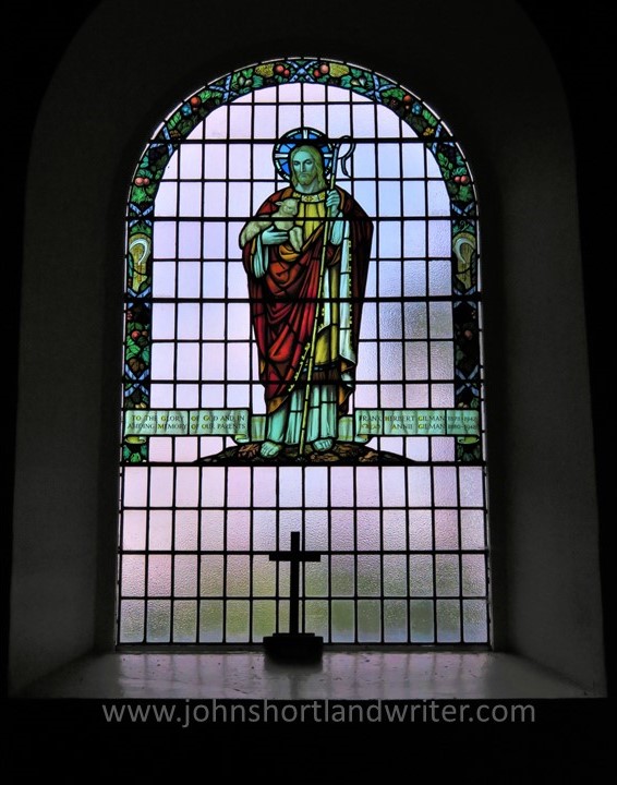
The stained glass is another miracle of survival for it is mostly complete. During the English Civil War (mid-1600s) many of the country’s churches and religious icons were damaged or destroyed with the Protestant dogma that followed. The Beauchamp Chapel’s glass was spared much of this with only its lower parts damaged. Although it cannot be seen in my photograph, it was hastily repaired – perhaps a little too hastily for Richard’s head and hands were replaced with those of a woman. The imagery depicts saints and angels in glowing colours, produced at huge expense. Musicians are shown with their instruments and a banner of sheet music runs across the entire window. The notations can be clearly seen and, as instructed by Richard, this is sung in the chapel each September with prayers said for his soul, a practice of huge significance in medieval times. There is a short YouTube video of the choir singing this original music in the chapel, as well as a brief history of the windows which can be found here.


Within the chapel are many other delights although none overshadow Richard. Tombs of his descendants, the Dudleys (through his eldest daughter Margaret), were placed there. They are resplendent in their own right but do not form a part of this blog. Even the prayer stalls, quite modest compared to other features of the chapel deserve close attention with their heraldic emblems carved into their timbers; they are fine in quality as well as detail. They can more briefly be shown by photos but deserve inclusion.


My family connection to the Beauchamps. When you travel back through so many centuries from the present day you are bound to uncover many ancestral grandparents. The problem is the discovering of them for in most families, as in the rest of mine, they lived very ordinary lives that were not well recorded if at all. Just occasionally, it is possible to find one that has risen to fame and this is the case with my paternal grandmother’s family. Granny Shortland’s relatives had been well-known up to the early-1900s for they held high positions within the Church of England and Government. A friend of Tennyson, the Reverend George Bradley had risen to become the Dean of Westminster Abbey. His brothers and sisters had also risen to fame in their spheres of work. These connections, known as ‘gateway ancestors’ enabled the research to progress relatively easily through time to Thomas Bradley – my 8th great-grandfather – who had been Chaplain to King Charles I and later, after the restoration of the monarchy, Charles II. From there the connections to the Beauchamps and even further back are well-researched by historians. It had always been whispered that Granny Shortland had married ‘beneath herself’ – now I know the reasons why!

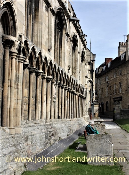
Visiting: The Collegiate Church of St Mary and The Beauchamp Chapel is open to visitors free of charge. Guided tours (which are well worth doing) are available at a modest cost, as is a climb to the top of the tower to view the town and beyond. Details can be found on their website here.
Warwick Castle is impressive and a popular attraction. It was the home of the Beauchamps but was built in the 11th century by command of William the Conqueror. It is possible to stay in the castle for short breaks. More details can be found here
There is a useful website (click here) if you are planning a visit to Warwick, which is situated a few miles south of the city of Birmingham and north-west of London.