A Walk by Stonehenge – part 2 – Woodhenge

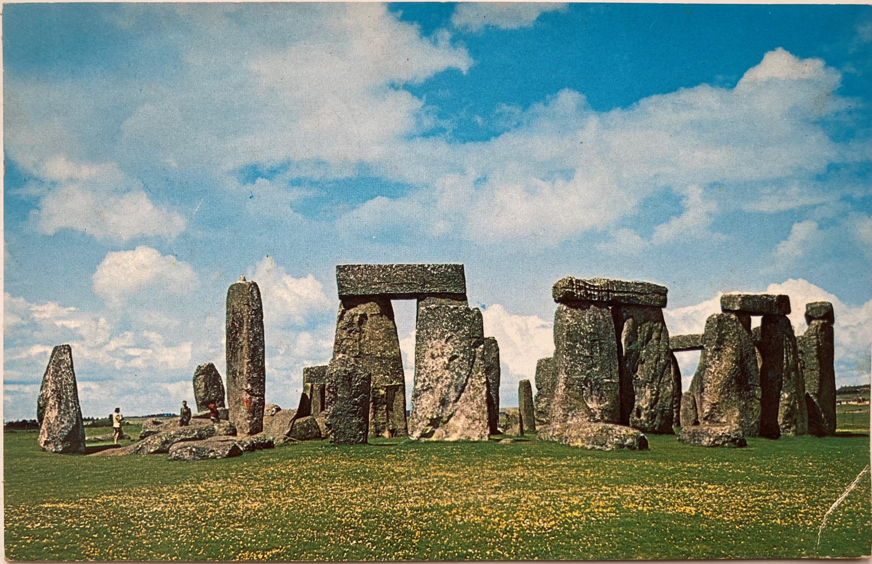
The prehistoric monument of Stonehenge was built in alignment with the sunrise of both the summer and winter solstices. For many, it is a sacred time and a moment to connect with our ancestors of 5000 years ago. With the Summer Solstice just days away it seems appropriate to write the conclusion of a relatively gentle walk that incorporates not just Stonehenge but also the nearby and lesser-known Woodhenge. Part 1 of the walk, along with photos, can be found by clicking on the link here.

The lesser-known circle of Woodhenge

Access to the stones of Stonehenge is usually restricted by a fence to prevent the one million visitors that view them every year from damaging the stones by touch, or by eroding the ground the stones stand on. For the solstice the fence is removed so that it is possible to walk amongst the stones and to witness the sun as it rises behind the Heel Stone. Thousands of people will attend the solstice but I prefer solitude for my walks whenever possible. I would choose to stand at the Cursus and to look down on the stones (and the crowds) or even to sit silently at Woodhenge.

A distant Stonehenge can be clearly seen from the Cursus

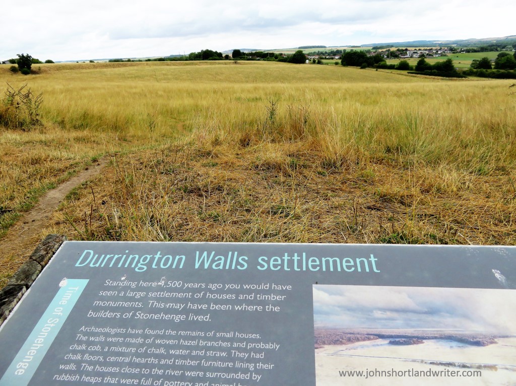
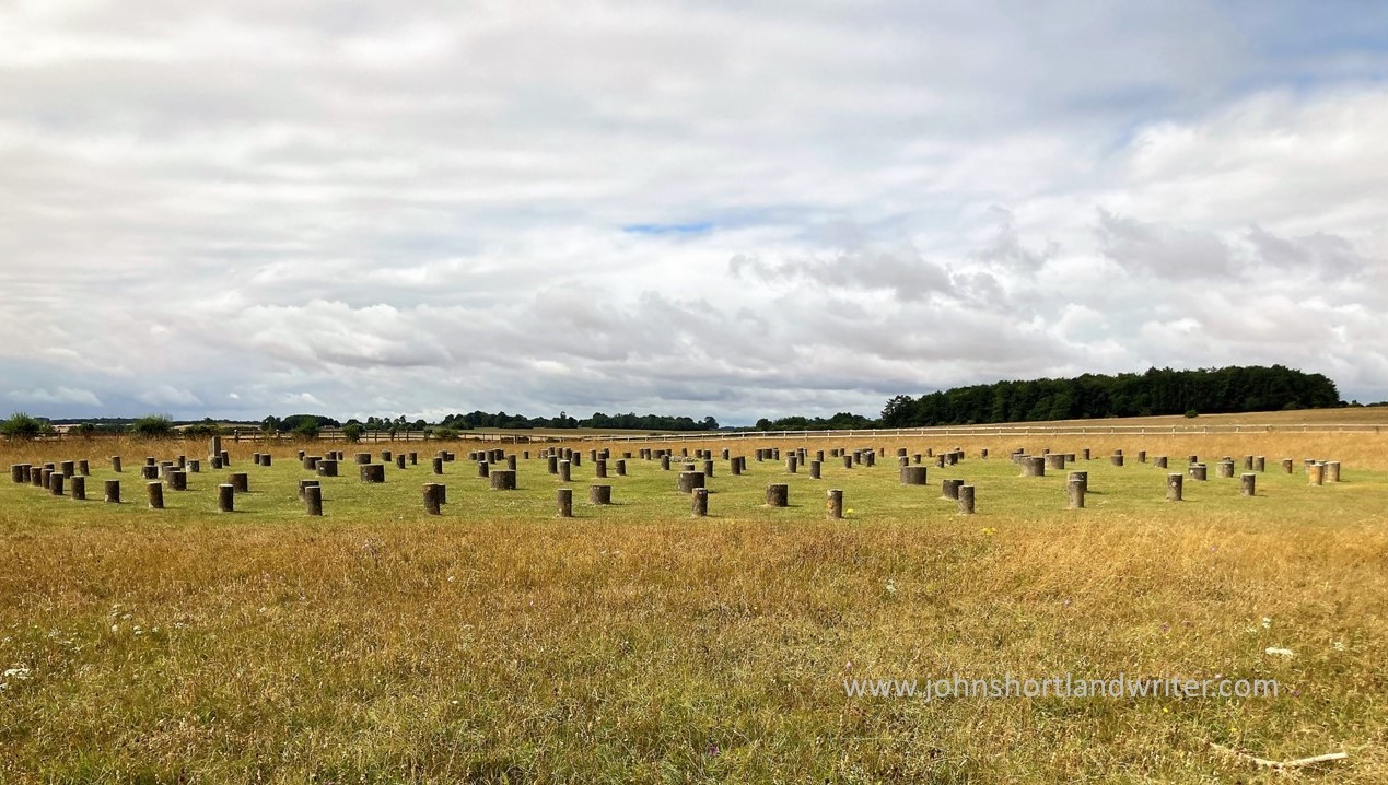
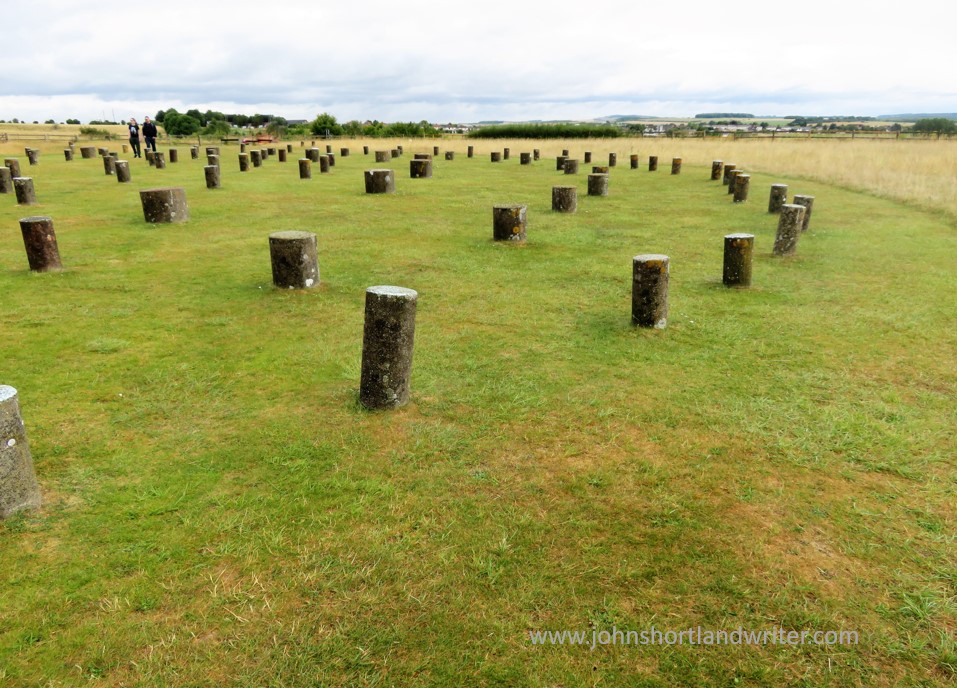
So what is Woodhenge? The official description is “a timber monument comprising of six oval rings of posts”. Not the most inspiring but the more you explore Woodhenge the more fascinating it becomes. Of course, the timber posts have long since rotted, and now their positions are marked by low pillars of differing diameters. As you walk amongst them and begin to picture the timber posts, the tallest of which reached 9 metres (30 foot) in height and weighed five tons, you realise just how awe-inspiring it must have been, especially if they were coloured or carved in some way.

Woodhenge as it may have looked 5000 years ago

Woodhenge was built at the same time as Stonehenge and on the same summer/winter solstice alignment. The two henges, two miles apart, were possibly connected by paths, one showing as banks and ditches is marked on maps as Stonehenge Avenue. The Cursus also is in direct alignment with Woodhenge and in those pre-history days the two monuments probably could be seen from these points.

Excavation of the site took place in 1926 but it is only now that more detailed studies are taking place. The initial dig discovered the body of a child at the centre of the circle and it was thought to have been sacrificed there. The remains were taken to London for later examination but were destroyed by bombing during WW2 before this took place. The grave is now marked by a small stone cairn. Other remains found within the circle were numerous pieces of pottery, butchered pig bones and, just outside the entrance, the body of a teenager. These finds indicate that activity at the site continued for many hundreds of years, long after the posts had rotted.

The site of the grave of the child is now marked by a cairn

Although the purpose of Woodhenge can only be surmised, the recent interest in it and its relationship to Stonehenge, Durrington Walls and other sites within the Stonehenge World Heritage Site, slowly reveal more connections between them. One such thought is that it may have held a spiritual connection with Stonehenge: the stones of Stonehenge being the enduring place of the spiritual world, whereas Woodhenge, with its feasting and slowly decaying timbers, the transformation of life towards death. Interestingly, similarities with ancient sites in Madagascar, although 4000 years later than those in England, can be found.

When I first visited Stonehenge as a child in the early 1960s there were far fewer people about!

To visit Stonehenge for free involves a walk not dissimilar to this one.  Park in Durrington village and take the public bridleway path (where it meets Fargo Road) directly south to Stonehenge.  The path passes the stones within yards of the public viewing path so you will still be separated from the stones.  Public footpaths continue southwards, criss-crossing an area rich in more barrows and other ancient earthworks.  With the help of an Ordnance Survey map it should be quite possible to make a longer, circular walk.

**Click on any of the images to enlarge**

Sources:
English Heritage Wikipedia

A Walk by Stonehenge – part 1

It is many years since I last visited Stonehenge, the prehistoric standing stones so closely attuned to the midsummer solstice.  Renowned throughout the world, it has been listed as an UNESCO World Heritage Site since 1986.  With fame comes numerous issues, not least how to cope with the estimated one million visitors that come to see them each year.  To prevent damage to the stones through soil erosion and, surprisingly, physical damage through the chipping off of ‘mementos’, the stones are now cordoned off.  This fencing is removed to allow access at the time of the midsummer solstice, a time when hundreds of people wait through the night for the midsummer sun to rise directly between the stones.  The image below is of a postcard that my great-aunt sent me in 1963 when the stones were much less frequently visited and reminds me of those early years when I used to play amongst them.

Stonehenge was far less visited back in the 1960s!

The Stonehenge World Heritage Site covers an area that includes other Neolithic standing stones close by.  A few miles away, and unlike Stonehenge, a place where you can walk amongst the stones every day of the year, is Avebury.  This circle is huge and considerably older than Stonehenge: flint tools dating back 9000 years show that early man was passing that way 4000 years before Stonehenge was built.  Avebury is the place to visit if you want to get close enough to touch the stones and it is also completely free to visit.  To visit Stonehenge can be quite costly although there is another way you can see the stones (legally) without paying if you’re prepared to walk – see below.

Avebury Stone Circle – part of the Stonehenge World Heritage Site

The third site, and to my mind, the best one for you will almost certainly have the place to yourself, is known as Woodhenge & Durrington Walls.  To be really impressed by this comparatively unknown place you do need to know some background information of its history plus a vivid imagination.  For me, it is such an atmospheric place to visit that the latter has never been an issue!  I recommend starting your walk here and walking inside the circle of Durrington Walls before exploring Woodhenge.  The first thing that is noticeable about Durrington Walls is that there are no walls!  The circular bank and ditch that surrounds the site was enormous and consisted of the bank itself which would have been several metres high.  The ditch originally was over five metres deep and, in places, up to thirty metres wide.  It is estimated that between four and six thousand people would have been needed to build the walls as well as the various houses and large timber circles associated with the site.  A feat quite remarkable nowadays let alone over four thousand years ago using just antler pickaxes!  Although nothing remains above ground now, apart from the bank, I found it very easy to imagine, as I walked alone and in silence, the bustle and noise of these industrious people.

Within Durrington Walls, now a grassy bank, up to 6000 people once lived
Information boards help you to understand the context of what you are not seeing!

Leaving Durrington Walls I made my way to the Cuckoo Stone, my only companions, sheep.  Now fallen, this stone would originally have been placed upright.  Looking at maps, it appears to be more, or less in line with the Great Cursus (more about that below) which in turn leads to Stonehenge.  The Cuckoo Stone, positioned 4000 years ago, continued to be ritually used into Roman times for in 2007, during archaeological excavation, a small building thought to be a shrine from that period was discovered. 

Close to the Cuckoo Stone a Roman shrine once stood

Leaving the Cuckoo Stone, my path led to an old track edged by wildflowers humming with bees and butterflies and bringing me out at the top of the Cursus.  The Cursus is another huge earthwork showing nowadays as a crop mark – two bright green stripes in an otherwise darker landscape.  If you compare my photograph with the one of the information board (below), I was standing at the opposite end.  In my image, the end of the Cursus can just be made out on the far horizon almost two miles distant.  The purpose of the Cursus is unknown but thought to be ceremonial as it is again aligned to the summer solstice.  It is even older than Stonehenge having been constructed several hundred years earlier.

The two-mile long Cursus now only shows as two grassy green stripes
The Cursus is better understood from this aerial photograph

Another good track took me due south before turning west to Old King Barrows and then back south to New King Barrows.  Before leaving the Cursus I stood to watch the visitors to Stonehenge some long way off and thinking how lucky I was to have all of this unseen history of the World Heritage Site to myself with only the song of skylarks as company.  More than five thousand years separated me from the Neolithic people yet surely, they must have stood here too and seen a similar picture as they made their way to join others already arrived, a humbling thought.

A distant Stonehenge can be clearly seen from the Cursus

The Old and New King Barrows consist of two groups, each of seven burial mounds so fourteen in total, separated by Stonehenge Avenue which is only visible as another cropmark.  The Avenue linked Stonehenge to the River Avon almost two miles away and was, perhaps, another route the Ancients would have taken to reach the stones. Despite their name, the Old and New King Barrows date from the same time period, and also around the same as Stonehenge.

One of the prehistoric burial mounds at Old King Barrows

It was by the barrows that I turned back towards Woodhenge, the last part of my relatively short but extraordinarily rich walk, rich both in its views and its wildlife, as well as its history.  As if to bring me almost up-to-date in time, the sound of an old-fashioned binder in an adjoining field was busy bringing in the harvest.  Not quite twenty-first century but a common sight less than a hundred years ago.

Harvesting wheat the old-fashioned way


The final part of my walk to Woodhenge can be found by clicking this link here.

To visit Stonehenge for free involves a walk not dissimilar to this one.  Park in Durrington village and take the public bridleway path (where it meets Fargo Road) directly south to Stonehenge.  The path passes the stones within yards of the public viewing path so you will still be separated from the stones.  Public footpaths continue southwards, criss-crossing an area rich in more barrows and other ancient earthworks.  With the help of an Ordnance Survey map it should be quite possible to make a longer, circular walk.

**Click on any of the images to enlarge**

.

The Silent Stones of Baltinglass

One and a half hours drive southwest of Dublin and close to the Wicklow and Carlow counties of Ireland lies the small town of Baltinglass. When I visited briefly a week or so ago, the town centre seemed very empty of people which gave it a certain charm as well as the impression that you didn’t come here if in need of excitement. Google searches appear to confirm it – a website that seems to have last been updated in 2013; even the Wicklow tourism website couldn’t find much to say that would bring the hordes flocking. Although these are all reasons why I would rather like it there is also another very good reason to visit Baltinglass and that is the remains of the Cistercian abbey founded in 1148 by the King of Leinster, Dermot Mac Murrough.

Baltinglas Abbey, Co. Wicklow (16) watermark

The dramatic entrance to Baltinglass Abbey

Baltinglas Abbey, Co. Wicklow (8) watermark

Today, the ruins consist mainly of the church although there would have been dormitories and other domestic buildings for the monks but of these there is no visible trace. The rather fine tower is of much more recent age for another church was built within the ruins in 1815, itself becoming obsolete by the 1880s.

Baltinglas Abbey, Co. Wicklow (5) watermark

The ruined tower of the 19th century church set within the much older ruins of the abbey

Many of the capitals of the stone pillars are heavily carved with decorations that are similar to the abbey ruins of Jerpoint 40 miles to the south. However, the finest of the stone carvings can be found mounted in a doorway – the tomb lid of James Grace who died 23rd February 1605, sixty-nine years after Henry VIII’s dissolution of the monastery. There are numerous other and later graves within the ruins but none as fine as the Grace memorial, for it continued to be used as a graveyard right up to recent times.

Baltinglas Abbey, Co. Wicklow (9) watermark

The intricately carved coffin lid of James Grace

Baltinglas Abbey, Co. Wicklow (10) watermark

Detail of the James Grace coffin lid

Entry to the ruins is free and compared to many other historic sites, little visited. Certainly, at the time of my visit, I was the only person exploring them. This gives the perfect opportunity to explore at length and to absorb the abbey’s silent history. Although the site is quite small, there are countless interesting features to be discovered and the equally tranquil River Slaney is just a field away, a place for yet further quiet contemplation.

Baltinglas Abbey, Co. Wicklow (4) watermark

Far from the Madd(en)ing Crowd

The title of this blog is actually rather a misnomer for the picturesque village of East Hendred is, in reality, quite close to both London and Oxford.  Nestling at the foot of the Berkshire Downs, its charm and ancient houses give it the appearance of a place far from civilisation and today’s frenetic pace of life.

East Hendred (13) copyright

East Hendred (9) copyright

A traditional English village centres around the ‘big house,’ the pub and the church and East Hendred can boast that its manor has been owned by the same family, the Eystons, for over six hundred years.  It has three pubs thereby bucking the trend in recent years of the many pub closures elsewhere that often sees the social heart of a community destroyed.East Hendred (18) copyright

East Hendred (2) copyright

There has been a village shop for very many years for a book published in 1922 (English Country Life & Work by  Ernest C. Pulbrook) shows it in a photograph.  Today, the shop is still “thriving and well-accustomed” although it is doubtful if it now sells the wooden hay rakes that are lined up outside on the early photo!  The building has remained unchanged over the years although the village changed allegiance in 1974 and is now in the county of Oxfordshire.  The shop is easily recognisable in my photograph as being at the far end of the row.East Hendred (1) copyright

East Hendred 1(a)

The church, dedicated to St Augustine of Canterbury, dates from the late twelfth century although its tower is later, built around 1450.  East Hendred (17) copyright

East Hendred (21) copyright

At the other end of the village is the former Chapel of Jesus of Bethlehem also built around 1450 by Carthusian monks.  Now known as Champs Chapel, it houses a small museum dedicated to the history of the village.  It is opened and maintained by volunteers.

East Hendred (6) copyright

Despite its historic past, the parish of East Hendred which is crossed by the ancient Ridgeway path (now a National Trail) is also firmly fixed in the modern day for it also houses the Harwell Science and Innovation Centre where the Diamond Syncrotron Facility is located.

East Hendred (16) copyright


A Day on the Oxford Canal

There’s nothing like messing about in boats on a warm, late spring day…

The building of the Oxford Canal was first brought into action with the passing of an Act of Parliament in 1769.  Beset with difficulties – mostly financial – its total 78 mile length wasn’t completed until 1790.  Linking the industrial Midlands region of England with the south of the country, the cost-cutting that was required has allowed the canal to claim it is one of the most scenic.   This is partly due to the canal following the contours of the land giving the canal numerous bends, rather than the more usual (and more expensive) building method of cutting a straight line through the landscape.

003   copyright

Although the northern section from its start at Coventry to Napton was straightened in the 1820s, the southern section to its end at Oxford where it enters the River Thames (giving access to London) remained unchanged.

016   copyright

Once completed the canal became one of the busiest and most profitable in England and, unlike many others, prospered even after the coming of the railways.  Barges carrying coal to London were still plying their trade as late as the early 1960s.  Today, the railway rules and often follows the same route.

058   copyright

However, the Oxford Canal is still one of the busiest waterways in the country, only now with leisure traffic.  On the day of our attempt at barging it was pleasantly quiet and we shared the canal with few others. The only hint of an industrial past was the working barges of the Canal & River Trust, the charity responsible for maintaining the two thousand miles of waterways in England and Wales.

025   copyright


Travelling at a speed slower than walking pace isn’t for everyone – I found it a little frustrating – but it does give ample opportunity to admire the scenery, buildings and wildlife.  The tithe barn at Upper Heyford, built around 1400AD, is magnificent.  More images of the barn, which is privately owned, can be seen by clicking here.


130   copyright

076   copyright

One of the cost-cutting methods used in construction was to incorporate a section of the River Cherwell into the canal.  The problem that this created with variable water flow is still an issue today.  Another saving more readily visible are the locks: fewer in number and deeper, many have single gates instead of the more usual two.

096   copyright

023   copyright

Manoeuvring such a large boat is a surprisingly quick skill to master but there are always other, more savvy boat people around that are happy to assist or advise when needed.  Our boat was hired from the yard at Little Heyford and we travelled north, meeting up with friends for a bankside picnic before returning to the marina.

101   copyright

A daytrip – or perhaps a longer holiday on a barge – is definitely to be recommended even though I found the pace a little too slow.  The next time I am on one I shall remember the words of Pooh, that wisest of bears:  “Rivers know this: there is no hurry.  We shall get there one day.”

133   copyright

Click on any of the photos to enlarge

Links:

The Oxford Canal – a more detailed history

The Canal & River Trust

Boat Hire – Lower Heyford


A Great Game?

A series of faded, sepia photographs have always been a mystery to me, just something else put into a cupboard and forgotten.  Handed down through the generations they recently came to light once more and looked at with renewed interest.  Who were these people and what connection might they have to my family? Two of the images were signed and with this name as my starting point the tale of their origin began to emerge.  The story that is unfolding only deepens the mystery for they were part of the ‘Great Game’, a term I hadn’t come across before.  Now, for me, it has two meanings: warmongering and my struggle to seek out the truth behind them.

003   copyright

Rudyard Kipling brought the ‘Great Game’ into everyday circles by using it in his novel Kim, published in 1901, although the term had been in use for many years before that.  It described the cat and mouse rivalry between the British and Russian Empires that lasted throughout the nineteenth century.

006   copyright

copyright   005

Britain, alarmed at Russia’s expansion southwards, feared that Afghanistan would be used as the gateway to an invasion of India.  To avoid this, troops were sent to install a puppet government in Kabul but within four years order was breaking down and the garrison was forced to retreat.  Caught in a series of ambushes, Afghan warriors slaughtered all but one of the 4500 troops and 12000 followers. By 1878 the British invaded again following the Afghani’s refusal to allow a diplomatic mission to visit. A treaty was signed and the army withdrew leaving a small staff in Kabul: in the autumn of the following year they were killed leading to full-scale war – the Second Anglo-Afghan War.  Travelling with the British army was a freelance photographer, John Burke, and it is his signature that appears on my photos.

007   copyright

copyright   004

History, as we all know, has a habit of repeating itself and sadly the rivalry between Russia and the West over Afghanistan has continued.  Inspired by John Burke, the war photographer Simon Norfolk has carried out a new series of images.  Intriguingly, he lists all of Burke’s plate numbers – the two of mine that are numbered are left blank so perhaps this is the first time they have been seen; rather an amazing thought.

copyright   002

008   copyright

All that is left now – and no mean feat – is to identify the places and the regiments and to find out where (and if) my family fit into all of this. I have been helped along the way by enthusiasts from a Facebook group.  One of them, Arnie Manifold, has an ancestor that fought there and it is his medals that are shown in the image below.  Wouldn’t it be extraordinary if we discovered his face on one of these old photos?

copyright   001

copyright   Second Afghan War Medals copyright Arnie Manifold

To view Simon Norfolk’s website and more information on John Burke, click here

To find out how a series of colourful postcards, brought back by my father from WWII, led to the discovery of a German fairy-tale castle, a love affair and an epic poem, click here.   

The Scottish Pineapple

The statement “I have been living in a Pineapple” may give cause for surprise but is, in fact, quite true for I have just returned from a brief trip to Scotland.  To stay in a building that puts a smile on your face whenever you catch a glimpse of it ought to be on everyone’s ‘to do’ list – if it is, The Pineapple is the place to go.

e226c-the2bpineapple2b42b2b2bcopyright

Originally part of the Dunsmore Estate, it was gifted to the National Trust for Scotland in 1974 and leased to the Landmark Trust who undertook its restoration.  Neglected for very many years, the Pineapple proved to be in remarkably good condition for every ‘leaf’ was designed to prevent water collecting within it and damaging the stonework.  The remainder of the property was very unstable and derelict.

The Scottish Pineapple

When the two walled gardens were enclosed at Dunsmore in the mid 1700’s there was no ‘big house’ attached.  They were purely used for producing a supply of fruit, vegetables and flowers to be sent to the Earl of Dunmore’s home in Argyll. It was some years later (it is thought) that the Pineapple was added as a folly and summerhouse, probably after the Earl’s return from Virginia and the Bahamas where he was Governor.

The Scottish Pineapple

Why a pineapple?  In the eighteenth century, pineapples were a rare luxury that had become associated with wealth and hospitality.  They began to appear on pillars, railings and weather vanes and, indoors on fabrics and wall coverings.  The building of The Pineapple was, perhaps, the grandest of all grand gestures.

aa16c-the2bpineapple2b122b2b2bcopyright

Although the building is of such high quality in both its materials, cratsmanship and design it was barely recorded in contemporary writing and its designer remains unknown.  One possible reason for this is that it may have been just a little too ‘over the top’ even for flamboyant Georgian taste.  It is even quite probable that the Pineapple may have been painted. The doorway of the undercroft is a very accurate timber carving of Ionic pillars beyond which stone steps lead to the raised northern lawn.  From this lawn there is level access to the summerhouse.

78a9f-the2bpineapple2b192b2b2bcopyright

Either side of the Pineapple are two small cottages, formerly gardener’s bothys.  These have been fully restored by the Landmark Trust to create holiday accomodation with living room and kitchen in one and bedrooms in the other.  The north garden and the Pineapple room are for the private use of guests, the south lawn and gardens are open to the public.

2daaf-the2bpineapple2b92b2b2bcopyright

ba5c7-p10403322b2

To be able to grow pineapples required specialist knowledge and skills as well as additional warmth.  Glasshouses flanked the south wall and were heated by the use of specially constructed hollow walls.  At the foot of these, fires were lit and flues within the wall drew the heat upwards, warming the brickwork.  The four decorative urns to either side of the Pineapple conceal chimneys and because of there similarity to those at Casino Marino in Dublin (to read about this extraordinary building click here), it has been suggested that the designer could be Sir William Chambers although there is no documented evidence to suggest this.   At intervals on the southern side of the walls I found sliding stones which could be removed presumably to allow the heat to escape.

a31b0-the2bpineapple2b312b2b2bcopyright

46745-the2bpineapple2b342b2b2bcopyright

In 1820 William Wilkins, architect of the National Gallery in London, designed a house in the Tudor Gothick style.  Dunsmore Park’s glory was, however, short-lived for by 1911 the family had left although it remained occupied until 1964 after which it was abandoned.  It is now a ruin visible across the fields from the Pineapple.  Another ruin, now very unstable, and also visible from the Pineapple, is the Elphinstone Tower.  Of earlier origin, built about 1510, it became the family vault of the Dunmore family in 1836 with a church built alongside a few years later.  This was demolished in the 1960’s.  Their fascinating stories will be subjects of this blog in due course.

The Scottish Pineapple

The Scottish Pineapple

With so much history and beautiful scenery close by – Loch Lomond is only a short drive away – the Pineapple makes a great and intriguing place to use as a base for exploring the area.  The grounds are open free to the public all year but the building is at its best during the hours when you are alone to enjoy its eccentricity and splendid isolation.

The Pineapple (6)   copyright

The Pineapple at night

Links:

The Landmark Trust

The National Trust for Scotland